How to read a sectional chart for the Part 107 test
Updated October 6, 2026 · 5 min read · Checked against the FAA Aeronautical Chart Users' Guide and 14 CFR §107.41
In short: every sectional chart question comes down to three steps. Find the place the question asks about, work out which airspace it is in from the line style and color, then compare altitudes in the same reference. Chart altitudes are above sea level (MSL); your 400-foot limit is above the ground (AGL).
Sectional charts are where most people lose points on the Part 107 test. The charts are dense, the questions point at one small area, and the test gives you the charts as figures in the FAA testing supplement. The examples below are from those same figures, so what you learn here is exactly what you will see on test day.
The airspace classes on a sectional
Each class of airspace has its own line. Learn these and most airspace questions answer themselves:
| How it looks | Airspace | Drone pilot needs |
|---|---|---|
| Solid blue lines with numbers like 100/40 | Class B, around the busiest airports | ATC authorization |
| Solid magenta lines with numbers like 41/13 | Class C | ATC authorization |
| Dashed blue line, ceiling in a dashed box like [25] | Class D, an airport with a control tower | ATC authorization |
| Dashed magenta line | Class E down to the surface around an airport | ATC authorization |
| Shaded magenta band (vignette) | Class E starting at 700 feet AGL inside it | Nothing below 700 feet AGL, which is usually Class G |
| No marking | Class E starting at 1,200 feet AGL in most places, Class G below it | Nothing in Class G |
The rule behind the last column is 14 CFR §107.41: you need prior authorization from ATC to fly in Class B, C or D, or in Class E that extends to the surface around an airport. How to get it is in our airspace authorization guide.
Worked example: the Savannah Class C
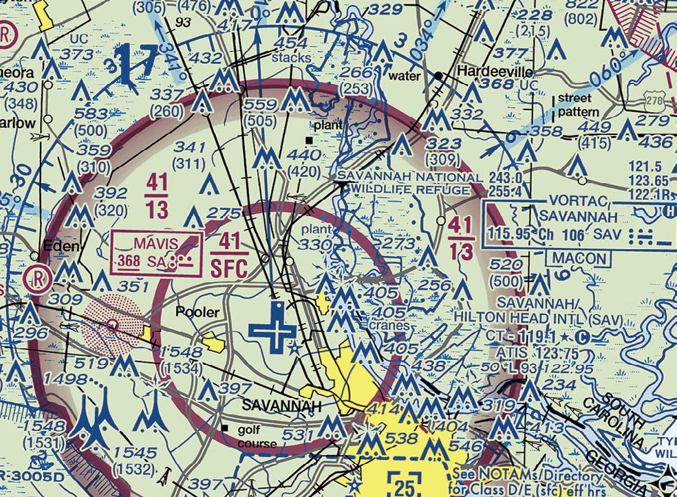
The two magenta circles are the Class C. Each has a pair of numbers, in hundreds of feet MSL: the top number is the ceiling, the bottom number the floor.
- Inner circle, 41 over SFC: Class C from the surface up to 4,100 feet MSL.
- Outer circle (the shelf), 41 over 13: Class C from 1,300 feet MSL up to 4,100 feet MSL. Below 1,300 feet MSL under the shelf, you are not in Class C.
So "What is the floor of the Savannah Class C airspace at the shelf area?" has the answer 1,300 feet MSL. The trap choice is 1,300 feet AGL.
MSL to AGL: the conversion that decides many questions
To know whether the shelf affects a flight at a given height, subtract the ground elevation from the MSL number. Savannah's airport elevation is 50 feet (the first number in its data block), so where the ground is near 50 feet the shelf floor is about 1,250 feet above the ground. A drone at 400 feet AGL under the shelf is well below it and outside Class C.
Reading an airport data block
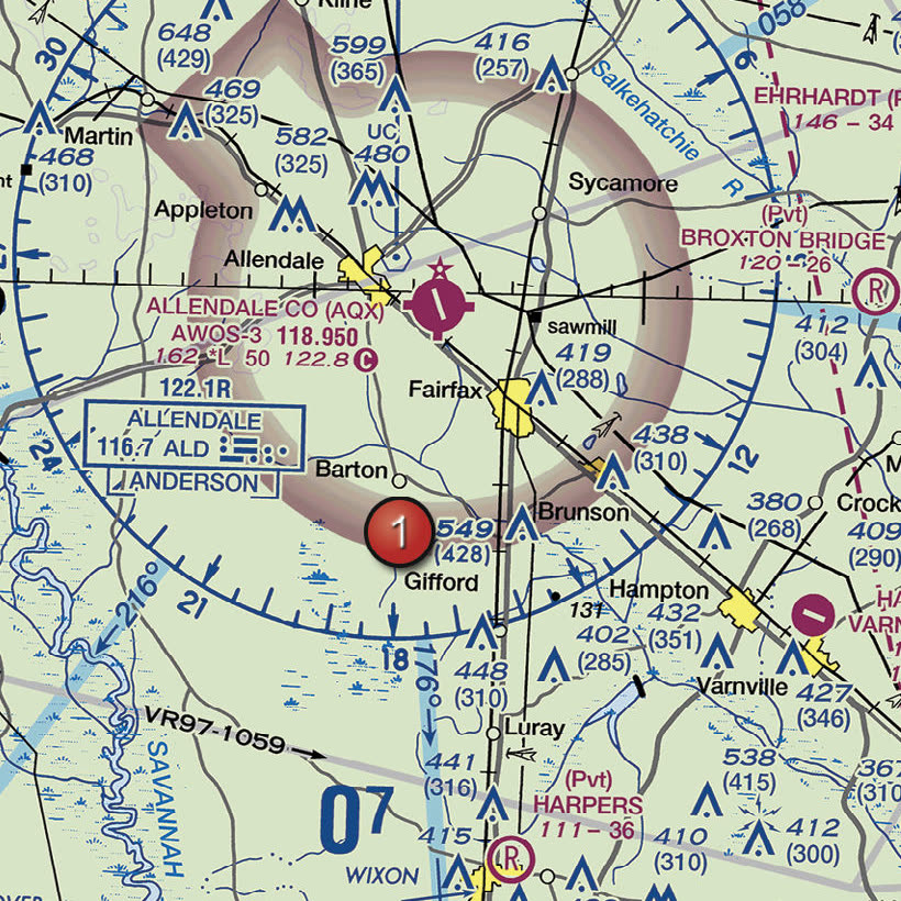
Allendale County is drawn in magenta, which means it has no control tower (towered airports are blue, like Savannah above). Its data block reads:
| ALLENDALE CO (AQX) | Airport name and identifier |
|---|---|
| AWOS-3 118.950 | Automated weather broadcast on 118.950 MHz |
| 162 | Airport elevation: 162 feet MSL |
| *L | Runway lighting with limitations; check the Chart Supplement |
| 50 | Longest runway: 5,000 feet (hundreds of feet, last two digits dropped) |
| 122.8 with a C in a circle | The CTAF, where pilots announce their positions |
Savannah's block adds two things: CT 119.1 ★ is the control tower frequency, and the star means the tower is part-time. ATIS 123.75 is the recorded weather and airport information. Some blocks also carry RP and a runway number, for example RP 17 at Millen in the next excerpt: the traffic pattern for runway 17 turns right instead of the standard left.
The shaded magenta band around Allendale is a vignette: inside it, Class E begins at 700 feet AGL instead of 1,200. A drone at 400 feet there is in Class G and needs no authorization.
Obstacles and maximum elevation figures
Towers show two heights: 549 (428) means the top is 549 feet MSL and the tower is 428 feet tall above the ground. The bold number is MSL, the number in parentheses is AGL. "UC" next to a tower means it is under construction. Groups of obstacles have their own symbol, and Savannah's excerpt even labels cranes.
The large number in each grid square, like the 0 and small 7 near Allendale, is the maximum elevation figure: the highest terrain or obstacle in that square plus a margin, in thousands and hundreds of feet MSL. 0 and 7 means 700 feet MSL.
Special use airspace and military training routes
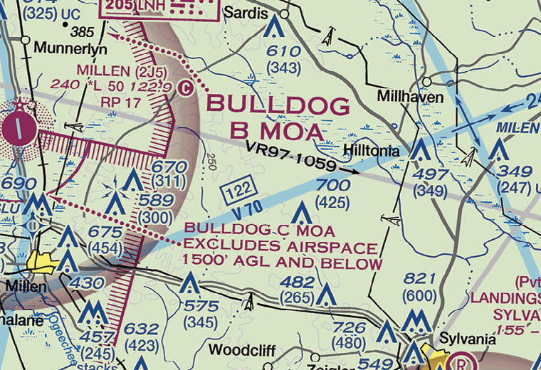
- Military Operations Areas (MOAs) have a hatched magenta border. They separate military training from other traffic. You may fly in one without permission, but check whether it is active, because military aircraft fly fast and low there. Notes like "excludes airspace 1500' AGL and below" give its floor.
- Restricted and prohibited areas have a hatched blue border and are labeled R- or P- with a number. You may not fly in a restricted area without permission from its using or controlling agency, and never in a prohibited one.
- Military training routes are gray lines labeled IR (instrument) or VR (visual). A four-digit number, like VR97-1059's 1059, means the route stays at or below 1,500 feet AGL. A three-digit number means at least part of it is above 1,500 feet. Expect military jets at high speed along them.
- Victor airways, the light blue bands like V70, are Class E from 1,200 feet AGL. They do not affect a drone at 400 feet.
Four mistakes to avoid
- Comparing MSL with AGL. Convert first. Chart airspace is MSL; your limit and cloud heights are AGL.
- Treating the vignette as a no-fly ring. It lowers the start of Class E to 700 feet AGL. Below that is usually Class G.
- Forgetting the dashed magenta line. Class E to the surface needs authorization exactly like Class D.
- Reading the wrong area. Questions name a numbered marker on the figure. Find it before you read the choices.
Check yourself
A typical Class C airspace area consists of
- Aa 5 NM radius surface area and a 10 NM radius shelf from 1,200 to 4,000 feet above the airport elevation
- Ba 10 NM radius surface area up to 10,000 feet MSL
- Ca 3 NM radius surface area up to 2,500 feet AGL
Show answer
A. a 5 NM radius surface area and a 10 NM radius shelf from 1,200 to 4,000 feet above the airport elevation
Class C usually has a 5 NM surface area and an outer circle of 10 NM that extends from 1,200 feet to 4,000 feet above the airport elevation.
Source: Remote Pilot Study Guide, Ch. 2
Class D airspace generally extends from the surface to
- A1,200 feet above the airport elevation
- B2,500 feet above the airport elevation, charted in MSL
- C4,000 feet above the airport elevation, charted in MSL
Show answer
B. 2,500 feet above the airport elevation, charted in MSL
Class D surrounds airports with an operating control tower and generally extends from the surface to 2,500 feet above the airport elevation, charted in MSL. ATC authorization is required.
Source: Remote Pilot Study Guide, Ch. 2
In most areas of the United States, where does Class E airspace begin?
- AAt the surface
- BAt 1,200 feet AGL
- CAt 14,500 feet MSL
Show answer
B. At 1,200 feet AGL
In most areas the Class E base is 1,200 feet AGL; in many others it is the surface or 700 feet AGL. Where no lower base is charted, Class E begins at 14,500 feet MSL.
Source: Remote Pilot Study Guide, Ch. 2
Federal (Victor) airways, shown as blue lines on sectional charts, are Class E airspace extending from
- Athe surface to 18,000 feet MSL
- B700 feet AGL up to but not including 14,500 feet MSL
- C1,200 feet AGL up to but not including 18,000 feet MSL
Show answer
C. 1,200 feet AGL up to but not including 18,000 feet MSL
Federal airways start at 1,200 feet AGL and extend up to, but not including, 18,000 feet MSL.
Source: Remote Pilot Study Guide, Ch. 2
A military training route labeled VR1207 on a sectional chart indicates a route
- Awith no segment above 1,500 feet AGL
- Bwith at least one segment above 1,500 feet AGL
- Cflown only under instrument flight rules
Show answer
A. with no segment above 1,500 feet AGL
MTRs with four-digit numbers have no segment above 1,500 feet AGL. Three-digit routes have one or more segments above 1,500 feet AGL. VR routes are flown under VFR, IR routes under IFR.
Source: Remote Pilot Study Guide, Ch. 2
What is the scale of a sectional chart?
- A1:250,000
- B1:500,000
- C1:1,000,000
Show answer
B. 1:500,000
Sectional charts are 1:500,000, so 1 inch is about 6.86 NM (about 8 statute miles). They are revised semiannually in most areas.
Source: Remote Pilot Study Guide, Ch. 11
Practice on every sectional in the FAA testing supplement. The app has 37 figure questions. Charts open zoomed to the area each question asks about, with the question pinned on top.
Sources
- FAA Aeronautical Chart Users' Guide
- 14 CFR §107.41, Operation in certain airspace
- Remote Pilot Study Guide (FAA-G-8082-22), Chapter 2
- FAA Airman Knowledge Testing Supplement (FAA-CT-8080-2H), Figure 23
Chart excerpts are reproduced from the FAA Airman Knowledge Testing Supplement, a U.S. Government publication in the public domain. They are for study only, not for navigation. Part 107 Test is not affiliated with the FAA.